Thursday, November 21, 2013

Map of our region of Patagonia

I thought I would give you a visual of where we kayaked.  Here are a couple of maps.  In the expanded view you can see several large features:  Pacific Ocean to the far west (left), Gulfo de Penas in the upper left hand corner, Isla Merino Jarpa is roughly in the center.  I drew a line denoting the route we took -- in blue/purple pencil.  To the North of Isla Merino Jarpa is the Northern Icefield and to the South you can see the Southern Icefield.  In Spanish they are called "Campo de Hielo Norte" and "Campo de Hielo Sur" respectively.  In the upper right hand corner of the map you can see the town of Cochrane which is the closest town to Valley Chacabuco (where we are now) and you can see Lago Cochrane, which is one of the lakes we will be backpacking next to in a few days.
Isla Merino Jarpa is roughly in the middle.

 Below is the same map but I zoomed in a little bit.  You can just barely make out Isla Sombrero which is the furthest west we went on our kayak expedition.  We could feel the ocean swell coming in from the Gulfo de Penas.  And you can also see the town of Tortel there on the map.  Tortel is just about at the end of the road.  There is a ferry that will take you a little bit further south, but if you want to drive all the way down past the Southern Icefield you will have to go back north and into Argentina, then head south and back into Chile.  The Careterra Austral doesn't extend all the way through the southern part of Chile.

In my next post I will show you what the students are up to currently, and where we are at.  Our backpacking section will start in just four days.  We will be backpacking for two weeks and then the students will have a cultural section where they stay with a Patagonian family for 8 days.  Then the semester ends and they will be off for Christmas break!  But more on all that later!

Home Stretch -- Chulengo style


We had some good weather as we neared our ending point: the small town of Tortel.  As we got closer and closer to the Rio Baker the water got more and more fresh and more opaque -- it was the influence of all the glacial melt in the area.  Our last campsite before Tortel was a place called San Rio Marlin.  There is a small fisherman's shack there and the beach is only semi-protected.  Before arriving there we had amazingly calm conditions, but as we approached the beach the wind (again) began to pick up a little.  We landed and unloaded our boats and before we new it there were 2 foot seas and white caps just off shore.  Once again we were glad to be safely on land.  The plan was to spend two nights there and finish up all the course paperwork including student evaluations.  Each student gets a thorough evaluation of how they've performed as an expedition member.  Categories for the evaluation are: Leadership, Expedition Behavior, Outdoor Living Skills, Risk Management, Sea Kayaking Skills and Environmental Studies.  Some of these students are taking this course for credit and will be able to transfer the credit to their own university and put the credit toward their major.

Luke made us a birthday cake to celebrate the Marine Corps Birthday.

The Marine Corps birthday was November 10th, so I happily woke Luke up that morning with a fine solo performance of "The Marine's Hymn" ...  Luke was in the Marines for a year and a half before being honorable discharged due to an injury sustained in a vehicle crash while training.  The LAV he was riding in rolled over when the driver tried to take it up too steep of a hill.  After getting out he decided to get some replacement adventure and education on a NOLS course in Patagonia.  It's been fun to have a fellow Marine on the expedition.
Our last morning of kayaking was touch and go (like other days but with a little more pressure to make a move).  As I went to bed the night before I noticed the wind picking up and started hearing it in the trees.  As I lay there in my tent I thought, "Uh oh, I hope we didn't miss our window to paddle our last 5 miles."  The trouble was we had a pick up scheduled and if the weather didn't allow us to move the next day we might have to delay our pickup and it could mess up the schedule for the coming days. Needless to say I didn't sleep very well that night wondering what the next day would bring.
When I got out of the tent at 6:30 am the next morning the weather was gusty and unsettled as was the sea state.  The student leaders of the day made an appropriate call to make a few preperations to get ready but then sit and wait for a window of calm.  At 8 am the weather did settle down a little and we decided to load kayaks.  Then it picked up again.  Then it mellowed.  We decided to get a boat on the water and see what it felt like out there.  Then the weather picked up again and we landed that boat.  As soon as it was on land the wind and seas calmed...  So then we decided we were going to have this fickle weather regardless... and we also knew we had less than two miles to go before we were in protection.  So we launched all the kayaks even though the weather wasn't great and started paddling down wind toward our point of protection in the Rio Baker.  We made it safely, and the students did a fine job of handling their kayaks and staying together as a group.  All the skills we had taught them and that they had been applying up to this point were put to good use that last day.  Way to go Chulengos!

Once we were in the river mouth we had a nice semi-leasurely paddle up stream (with the help of a tail wind) against the current.  But within a couple of hours we were unloading our kayaks on shore in the same place we had started 25 days prior.  We had a good debrief that night and played a fun game then went to bed.  The next morning the bus picked us up and we began the drive to our next section in Valle Chacabuco:  Wilderness First Responder training.  As we travelled through the low mountains it began to snow!  Not unheard of for this time of year (early spring) but somewhat unusual.  Hopefully it will warm up a bit before we go backpacking in a few days!
Some snow on the road down to about 1000 ft.

Tuesday, November 19, 2013

Curious George and the Man with the Yellow Hat

 So, Halloween was Jimmy's birthday... so Isi (on the right in the picture) made him a very nice cake... and improvised a candle.  People were dressed up -- I don't know if you can tell?  In the middle is Hunter dressed as Curious George, and the Man with the Yellow hat is to the right of him.  We had super hero show up, and knight in shining armor, Facebook Man, came... and several others.
 We left Isla Sombrero after spending two nights there and then we began heading back toward Isla Merino Jarpa.  Once we arrived at the very west end we turned north again to begin making our way back to Tortel by way of the north side of the Island.  The north side of Isla Merino Jarpa is amazing... lots of steep granite walls, ancient looking ferns, and many, many waterfalls.
 Here we are traveling back east.  The weather continued to change daily.  Some days it rained all day, other days were cloudy with little rain but lots of humidity, and then occasionally we would get a sunny day.  When you are living outside for weeks on end you really appreciate the sun!  But, Patagonia is so beautiful even when it's cloudy and the weather is inclimate.  The extremes are why many people come to visit and why very few people live here!
 Eventually we made it to Coleta Guillardo, a shallow beach about 20 miles from our ending point.  We gave the students the option of pushing on and trying to travel up to the Stephenn Glacier.  But with just 5 days left to get to our pick-up we would really have to push it.  In the end the students decided to take a more relaxed approach to the last few days of sea kayaking and do some day hiking and exploring on land that we hadn't had time for thus far.  Coleta Guillarda was a good place for hiking because the forest here is thin and there is a lot of open rocky space to get up high and see the views

Isla Sombrero

During the second ration period, which was 8 days, we continued west through Canal Baker toward Canal Messier.  Our original plan was to cross Canal Messier and explore the archipelago that is further west.  But it can be a big commitment to cross Canal Messier because it runs north and south and tends to funnel the weather.  So, just because you get a good window to cross one direction doesn't necessarily mean you'll have an easy time crossing back.  So, because of the amount of time left in the course and the other goals we had in mind to accomplish with our remaining days, we decided to set our sights for Isla Sombrero to the north and go check out that Island.

Crossing Canal Baker toward Isla Zealous
On my birthday, which was October 29th, I woke up to a beautiful sunrise!  A very nice birthday gift!  The previous day had been very calm and great for paddling, especially for crossing Canal Baker.  But you know the saying, "Red sky in the morning, sailors (and kayakers) take warning."  As we loaded our boats and began to get on the water that morning we noticed the wind picking up in the distance.  In fact, you can see a faint wind line on the horizon in this picture to the right.  We needed to paddle north 15 miles or so to get to Isla Sombrero, but as we made our way the wind continued to build.  We travelled for several miles and hadn't seen a good pull out in a while and knew there might not be much until Isla Sombrero.  But getting to Isla Sombrero required several more miles of kayaking and a one mile crossing in more exposed waters.  So, in light of the circumstances and building weather conditions, we decided to turn around and head back to a beach we saw along the way in our first two miles of travel.  This beach we nicknamed "shrimp beach" due to the little shrimp-like creatures that were hopping all over the beach at night.  We spent one night there and hoped to have a window to travel the next day.
 
Isla Sombrero in the distance...
When we woke up the weather was blustery and we could see some wave action in the distance.  We decided to watch the conditions while we cooked breakfast and then meet again to make a decision as to weather to pack up camp and give it a try.  At 8:00 am, after eating some breakfast biscuits and drinking our coffee, we decided to pack up and give it a go.  Once we were on the water we still had some wind coming and going, but if it didn't deteriorate much we thought we'd be successful.  Once we got to the area that we would have to make our crossing from, we could see more white caps and were feeling more energy in the water, so we retreated to a protected cove to make a decision.  While we sat in the cove eating our snacks and drinking water, the weather began to improve-just a little bit.  A few more minutes went by and we decided to paddle out again and look at the crossing one more time before committing to it.  Sure enough when Isla Sombrero was in view we could see the sea state between us and the Island was much calmer than just 30 minutes ago, so we started our crossing.  As we travelled the water became calmer still as we neared the lee shore of Isla Sombrero.  There was a residual swell of 1-2 feet wrapping around the island from the open ocean to the north, so landing on much of the rocky shore line wasn't an option.
Rock wall made by indigenous people long ago.
We could see from the chart that there was a small bay indicated in the center of the southern shoreline.  We decided that was our only good option at this point and so we headed for it.  There was a lot of kelp growing in the water and the view to the west was beautiful!  As we neared the small cove I could see that it was going to be a nice protected spot to land.  What a good feeling to paddle into protection!  Sure enough there was plenty of room to land our boats and we began to scout for camping options.  Right away I noticed a rock wall in the intertidal zone that indicated this was an area frequented by the indigenous people long ago.  They would build fish traps on these shallow beaches -- at high tide the fish would swim in through an opening and then they would use a woven net to block the exit as the tide dropped back down.  It also appeared that the indigenous people had cleared spaces on this beach to land their canoes.  It looked like three neatly prepared parking spots at low tide.
Our scouting had revealed some nice camping options in the woods, which was great.  We decided since the next day was Halloween and one of our student's birthday (Jimmy) that we would take a layover day and spend two nights here.  We got to sleep in a little bit and then met for some classes and reflection time the following day.  Then in the afternoon we got on the water in the protected bay and practiced some self rescues and bracing skills in the single kayaks.  The sun even came out!!  By evening time we cooked dinner and then met for a little Halloween party and birthday celebration.  I'll see if I can get a few photos of the costumes in my next post.  Once we went to bed that night the wind began to blow pretty hard and huge gusts ripped through the trees throughout the night.  Thankfully we had nice protection there in the woods. Then at about five o'clock am the last gust blew and the weather calmed down a lot.  We watched the weather for a little while and then decided to pack up camp and move... the adventure continues....

Saturday, November 16, 2013

Hot drinks and kayak repair

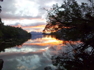
The boats dropped us off at Punta Rachel, a nice little beach on the south side of Isla Merino Jarpa.  The Island of Merino Jarpa is nestled between the Northern and Southern Icefields of Patagonia.  An icefield is a huge conglomerate of glaciers that covers an enormous piece of mountainous terrain... and the reason those icefields are there is because there is a huge amount of precipitation throughout the year AND cold temperatures.  We experienced both!  :)  But, that being said, we did get a handful of dry days and even three or four sunny ones!  We appreciated them both.

During the first ration we focused on getting to know one another, learning how to camp in a wet/cold environment, how to cook and bake, how to kayak and we also got started on some of our leadership curriculum. 
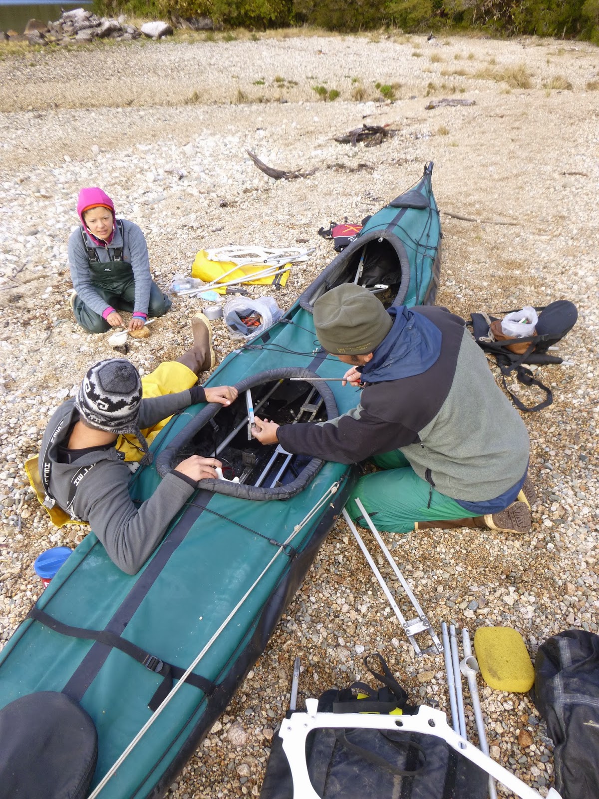
Feathercraft kayak repair.
 After our first day of skills training we began to notice that a few of our sea kayaks had been damaged during transportation.  These kayaks are designed to be collapsible and are made with an internal aluminum frame and a rubberized outside "skin".  They also have two inflatable tubes that run along the sides which when inflated help tighten up the skin around the frame.  Well, a couple of the inflatable tubes (called sponsons) were punctured, so we had to patch those, and one boat in particular had a damaged frame.  So we got out the little hacksaw and some aluminum tubing to use as a splint and we went to work.  In the end the boats worked great and stayed afloat! :)

In the picture on the left you can see Lloyd and two students working on the boat repairs (Jack and Isidora).  When these boats are taken completely apart they can be packed into a large piece of luggage and taken on an airplane.  Pretty cool.


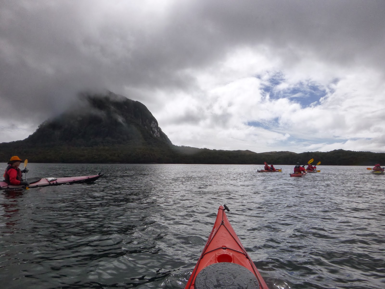
Paddling west in Canal Baker.  Fresh snow at 500 feet.
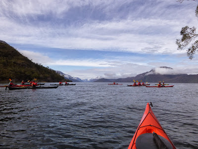
 After a couple days of basic kayak training and paddling around our protected bay, we decided we were ready to venture out into more exposed waters and move our camp to the west further along Canal Baker.  We had a strong headwind and were only able to make about seven nautical miles that first day.  Then the next day we made about another seven miles.  Eventually we got to a good camp where we decided to take a layover day and do our re-ration and teach the students some necessary classes to prepare them to be Leaders of the Day. 
Dinner and hot drinks.
    
This campsite is in a small bay called Puerto Lorenas.  We took one intentional layover day here but then the wind picked up for a couple of more days and we weren't able to move... well we tried... got all packed up and paddled out to the mouth of the bay, but the waves were 2-3 feet tall and breaking.  We got a little feel for it, but turned around and went back into our sheltered cove.  We affectionately named that camp "Ewok Village" because for the most part we were camped in the woods.  Abbey, one of the other instructors, is a very good cook, and made some excellent meals... can you tell what that one is?  Looks like bow-tie pasta something-er-other.  Delicious.  She and I quickly learned that to keep Lloyd happy we had to give him several hot drinks per day... you can see him here enjoying one in his Nalgene bottle.  He likes hot cocoa the best.  He and I will also be working together on the backpacking section coming up in seven days.  
Punta Ana... arriving and unpacking the kayaks.


 This is a fairly typical looking "beach" in the area we were kayaking.  This area around Isla Merino Jarpa has so much fresh water coming into it that the water isn't very salty and therefore the intertidal life is sparse.  As we traveled further east we saw more and more barnacles, mussels and other marine wildlife.  After pulling up on a beach we would unload the kayaks completely, move the kayaks up into a safe spot above high-tide and then begin setting up camp.  Sometimes there was space on the beach and other times we had to look for little nooks and crannies in the woods.  The "Chulengos" got to be very good and very creative campers! 

Friday, November 15, 2013

The Puffy Jacket Paddling begins

Hello everyone!  We left the NOLS base on October 14th and began the long drive down to Tortel where our kayak expedition began.  There is only one main road traveling north to south in Patagonia called the Carretera Austral.  It would be the equivalent of I-5 in Washington and Oregon except that much of it isn't paved!  But it's a beautiful drive through the mountains to the sea.

This is the main highway in Patagonia... the mountain is Cerro Castillo.
We stopped for a roadside picture.  This is the Rio Baker headwaters.  

 Once we arrived in Tortel, we set up camp, cooked some dinner and got a good nights sleep.  The next morning we waited along the bank of the Rio Baker (Baker River) for our two boats to arrive that would take us 21 miles out amongst the islands and drop us off to start our kayak expedition.  Once we got out in the more open water of Canal Baker we had some rough seas, but we made it safely to our first camp: Punta Rachel.


Here is our boat... we are loading all our gear and rations...
This is the second boat that has all of our kayaks loaded into the bow.  Plus four students and an instructor.  Full load!  Eventually the seas got a bit rough and the kayaks took a bit of a beating.  But we transferred all the people onto the bigger boat while it was still calm.  Pretty nice weather, huh?  We did have some sun off and on during the kayak section, but we got our fair share of wind and cold.  We even got some snow flurries a few days after this shot was taken. 
Here are most of the students riding on the bigger boat.  You can see Will and Peter in the front row... Jimmy, Isi, Jack and Devon in the second row... hunter poking his head out on the right... and Abbey and Elle there in the back. 

Well, it takes about 10 minutes to upload one picture here at the Valle Chacabuco Park where we are now staying.  I will continue to add photos and stories from the past 25 days... and then eventually I will have you all caught up on the adventures we've been having.  At the moment the students are here at Valle Chacabuco, Concervacion Patagonica, participating in a Wilderness First Aid course that will last nine more days.  They just got out for lunch, so I'm going to run and get some food too!  Thanks for all your thoughts and prayers and for looking at my pictures and captions.  Everyone is healthy and happy and we are learning a lot down here!  See you soon!  --  John