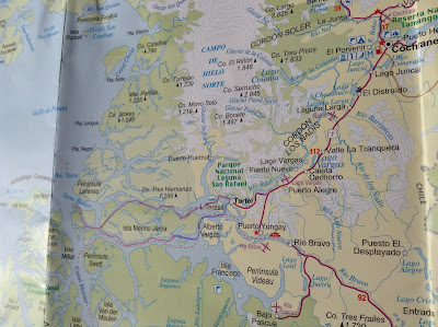
I thought I would give you a visual of where we kayaked. Here are a couple of maps. In the expanded view you can see several large features: Pacific Ocean to the far west (left), Gulfo de Penas in the upper left hand corner, Isla Merino Jarpa is roughly in the center. I drew a line denoting the route we took -- in blue/purple pencil. To the North of Isla Merino Jarpa is the Northern Icefield and to the South you can see the Southern Icefield. In Spanish they are called "Campo de Hielo Norte" and "Campo de Hielo Sur" respectively. In the upper right hand corner of the map you can see the town of Cochrane which is the closest town to Valley Chacabuco (where we are now) and you can see Lago Cochrane, which is one of the lakes we will be backpacking next to in a few days.
 |
| Isla Merino Jarpa is roughly in the middle. |
Below is the same map but I zoomed in a little bit. You can just barely make out Isla Sombrero which is the furthest west we went on our kayak expedition. We could feel the ocean swell coming in from the Gulfo de Penas. And you can also see the town of Tortel there on the map. Tortel is just about at the end of the road. There is a ferry that will take you a little bit further south, but if you want to drive all the way down past the Southern Icefield you will have to go back north and into Argentina, then head south and back into Chile. The Careterra Austral doesn't extend all the way through the southern part of Chile.
In my next post I will show you what the students are up to currently, and where we are at. Our backpacking section will start in just four days. We will be backpacking for two weeks and then the students will have a cultural section where they stay with a Patagonian family for 8 days. Then the semester ends and they will be off for Christmas break! But more on all that later!

No comments:
Post a Comment